Cooperation among developing nations on science and technology is often hard to see, but China and Brazil are leading a revolution. A treaty signed by both countries in 1988 for a joint effort to build satellites has turned into one of the world’s most important scientific programmes between two emerging economies. As well as fostering crucial domestic investments in research, the partnership is also gaining global significance as Sino-Brazilian technology is picked up by other poor nations.
Since 1999, the programme, known as CBERS (China-Brazil Earth Resources Satellite), has put three satellites into orbit (CBERS 1, 2 and 3), each weighing 1.5 tonnes and launched by Chinese rockets at the Taiyuan Satellite Launch Centre, in northern China’s Shanxi province. Each carries a kit of optical instruments, such as low- and high-resolution cameras.
Built almost exclusively with national components, the devices have already provided 175,000 images for Brazil and China. The initiative is nourishing a unique domestic space industry in each country and represents an important step towards making China and Brazil independent from data produced by commercial remote sensing companies and space agencies in developed countries.
The CBERS family is doing similar work to NASA’s famous Landsat and Europe’s highly precise SPOT, both operative since the 1980s. The satellites monitor terrestrial and atmospheric dynamics such air moisture, agricultural land use, coastal floods and forest fires. The difference is that having their own long–term programme allows Brazil and China to obtain cheap remote sensing data to support public policy.
“We cannot rely only on images from other countries’ satellites. The Landsat, because of its age, may fail at any moment,” explained Marco Chamon, general coordinator of satellite technology for the Brazilian National Institute of Space Research (INPE). “We need the security of knowing that we are going to receive data for a long time.”
The Chinese government is also satisfied with the programme. China has used CBERS images mainly for urban planning and to measure agricultural yields. By viewing changes in land use it is possible, through satellite images, to estimate the effects of a specific drought or rainy season.
Ding Xiaobo, a researcher from the Chinese Academy of Space Technology (CAST), points out that CBERS played a central role in the relief efforts for last year’s earthquake. “On May 12, CBERS images helped us understand the extent of the disaster and to plan relief strategies”, he explained in a telephone interview from his office in Beijing.
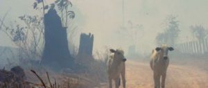
For Brazil, CBERS has enabled the development of the most accurate and comprehensive system of deforestation monitoring in the world. Using CBERS’s high definition cameras along with images from the US Landsat, the Brazilian government obtains a clear picture of what is happening in the Amazon every year. Every 15 days, lower quality images reveal deforestation trends, helping the national environmental agency to take timely action on illegal timber harvesting. Since 2004, deforestation rates in the Amazon have been halved.
Besides its domestic impacts, the CBERS programme is due to change the way remote sensing is used (or commercialised internationally). When satellite 2B launched in 2007, China and Brazil decided to adopt an open data policy, which means that any country which builds a receiver on its territory will have free and unlimited images from the Sino-Brazilian satellites. The first to jump on the bandwagon was South Africa, which last year started to build installations for data analysis. Ding Xiaobo revealed that discussions are also underway with Ghana, Egypt, Ethiopia and others. “I believe that we are going to influence other countries with our policy”, he says.
Chamon agrees. “One of the aims of our partnership it is geopolitical. For example, we already provide our neighbours with any image or data that is important for them.” Brazil, he said, aims to become a world provider of tropical deforestation monitoring expertise, specifically to countries in central Africa and southeast Asia, and has established a special centre in Belem, a major city in the Amazon forest.
Under a 2002 agreement, two more satellites (CBERS 3 and 4) will be launched by 2014 in order to guarantee the continuity of the programme. In addition, Brazilian and Chinese authorities met in Beijing to discuss an even more ambitious plan to launch a family of radar satellites to allow detailed geological surveys.
The two delegations agree that the partnership is an example of success at a moment when technology transfer is one of the issues under discussion for the new climate agreement that will be concluded in Copenhagen in December. Most of the debate so far is over the difficulties of establishing common scientific goals. For Brazil and China, at least, the cooperation is already happening.
Gustavo Faleiros is Brazilian journalist who specialises on environmental issues. He also writes for O Eco Online
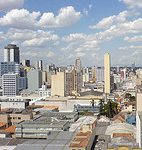
Homepage photo by CBERS