[Download Kenneth Hewitt’s full report here]
As we saw in part one, climate change is obviously having different consequences in different mountain areas of Asia. The situation in the Karakoram must represent some distinctive conditions. Three features of the regional environment seem critical. The first two relate to snowfall and the nourishment of these glaciers. They are intermediate in type between the summer accumulation (snowfall) glaciers of the greater Himalayas, and the winter accumulation glaciers of, say, the Caucasus and European Alps to the west. In each of the latter, more or less strong glacier retreat is reported. Second, the zone of maximum precipitation in the Karakoram is much higher than in these and most other mountain ranges. It is also entirely within the accumulation zones of the glaciers. This relates to the third factor, the exceptional elevations and, especially, elevation range of these ice masses.
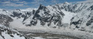
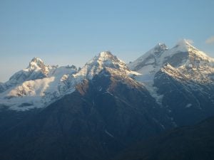
The glaciers of large and intermediate size originate at very high altitudes and many of them descend much lower than elsewhere in the sub-tropics. Five glaciers span more than 5,000 metres in elevation, 15 over 4,500 metres and more than 30 over 3,000 metres. In the Hunza valleys of the central Karakoram, glacier termini advance below 2,300 metres above sea level. Those on the north flank in the Yarkand drainage do not descend so low because the valleys are at greater elevations, but they include several descending more than 4, 000 metres, due to location in the very highest parts of the range around K2 (8,610 metres). All of the glaciers recently observed to be growing are in these high-relief basins. Of special interest, but poorly understood, is how elevation and topography interact with the regional climatic influences to determine the behaviour of the glaciers.
The regional climate of this south-western part of the Inner Asian mountains comes under the influence of three different, seasonally varying, weather systems. First, the winter half of the year is dominated by a westerly or “sub-Mediterranean” circulation. Second, in summer, moisture comes from the Indian Ocean to the south and the climate becomes “sub-monsoonal”. Third, inner Asian high-pressure systems, especially involving the Tibetan Plateau, interact with the other two systems to affect storm paths and the incidence of clear weather. The last is critical, since direct solar radiation is responsible for 80% to 90% of melting on the glaciers.
Global climate change is expected to alter the absolute and relative roles of all three systems, a likely factor in recent developments that complicates forecasting of future glacier changes. Meanwhile, investigations on the glaciers at higher elevations have revealed how different conditions are from the valley weather stations – mostly below 3,000 metres above sea level – whose records had dominated climatic interpretations.
Station records from the inhabited areas of the Karakoram show two-thirds or more of precipitation occurs in winter, mainly February through May. The average annual precipitation in these valleys is 150 millimetres to 300 millimetres water equivalent – an arid or semi-arid environment with severe summer drought. However, a very different story emerged from our measurements on the glaciers in the 1980s. At elevations above 4,800 metres we found that snowfall amounts are roughly the same in summer and winter, with roughly equal amounts coming from the west and the Indian Ocean. Summer drought was not observed on the glaciers especially in their accumulation zones above 4,500 metres above sea level.
Moreover, the zone of maximum precipitation turned out to be between 5,000 metres and 6,000 metres above sea level – much higher than in, say, the eastern Himalaya or any other reports from tropical mountains. Moreover, accumulation zone snowfall is equivalent to between 1,000 millimetres and 2,000 millimetres of water; far more moisture than the valley stations suggest. What is identified here is a powerful gradient in climatic conditions with elevation – a five- to 10-fold increase in precipitation from glacier termini around 2,500 metres above sea level, to where the snow falls that nourishes the glaciers. A recent, pioneering study based on satellite imagery – conducted by Bibi S Naz and colleagues at Purdue University in Indiana – suggests snowfall amounts and the extent of perennial snow cover have increased in the past couple of decades at high elevations in the Central Karakoram.
Summer storm on the Baltoro Glacier at 4,600 metres above sea level, at the limit of rain(below) and snowfall (above). The exceptional height to which there was rain seems to reflect climate warming. However, at the height of the ablation season the storm virtually shut down melting here and greatly reduced it lower down. (Photograph/Kenneth Hewitt August 2005)
Vertical gradients also define key conditions for the melting of the glaciers, and their contribution to water supply. In fact, although many ice tongues descend much lower, the decisive conditions for melting occur between 3,800 metres and 4,800 metres above sea level. Here lie more than 80% of the ice surfaces where melting occurs in summer. Ablation conditions – under which ice melts – also identify complexities that arise with timing and seasonal rhythms as well as elevation. Nearly all the melting and water production of the glaciers occurs in just a few weeks of summer, when temperatures rise above zero and strong sunlight occurs. In turn, this explains why 70% to 80% of the flow of the upper Indus and Yarkand rivers occurs in six to 10 weeks of summer – usually in July and August – lagged until winter snow sitting on the ablation zone has melted away to expose the ice.
Moreover, melting is very sensitive to summer cloud cover or storms. A sudden summer storm can shut down melting for days at a time. Just when and for how long rapid and extensive melting occurs varies greatly from week to week, and year to year. It is one of the most sensitive variables affected by climate change.
Middle ablation zone of Biafo glacier after the first winter snowfall in October, 2009. The main glacier is over 500 metres thick here and 3.5 kilometres wide. (Photograph/Kenneth Hewitt 2009)
Another huge and poorly understood fact is that most Karakoram glaciers are largely or wholly avalanche-fed. The accumulation zone areas of these glaciers, above about 4,600 metres above sea level, are generally 70% to 80% steep rock walls. The larger part of high altitude snowfall in the region is on to these unstable slopes, and is avalanched more than 1,000 metres before incorporation into a glacier. It seems likely that changes in snowfall amounts, with season or in storm intensities, will alter the timing, temperature relations, and extent of avalanching. This can, in turn, affect glacier behaviour. The trouble is, there are no data or research to help predict what climate change does to this all-important part of the nourishment of the glaciers.
All-season avalanches that descend to the surface of Barpu Glacier are the main way ice is nourished. This one falls more than 2000 metres, is two kilometres wide and will travel several kilometres down the glacier. (Photograph/Kenneth Hewitt. August 2006)
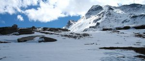
What can be said is that what happens between 3,800 metres and 7,000 metres above sea level is absolutely critical to the role of climate and climate change in glacier behaviour and survival. These are also the elevations where the reasons for the seemingly anomalous recent responses of Karakoram glaciers must be sought. However, it is here that the least research has been done. There are no permanent measuring stations or long-term monitoring. To recognise how unfortunate that is, we need to address changes that are, or may become, unusually threatening to human communities and activities.
NEXT: Risks and responses
Kenneth Hewitt is professor emeritus in geography and environmental studies and research associate at the Cold Regions Research Centre at Wilfrid Laurier University in Ontario, Canada.
Homepage image by Kenneth Hewitt shows icefall on Charakusa Glacier, east-central Karakoram in June, 2005.
[Download Kenneth Hewitt’s full report here]